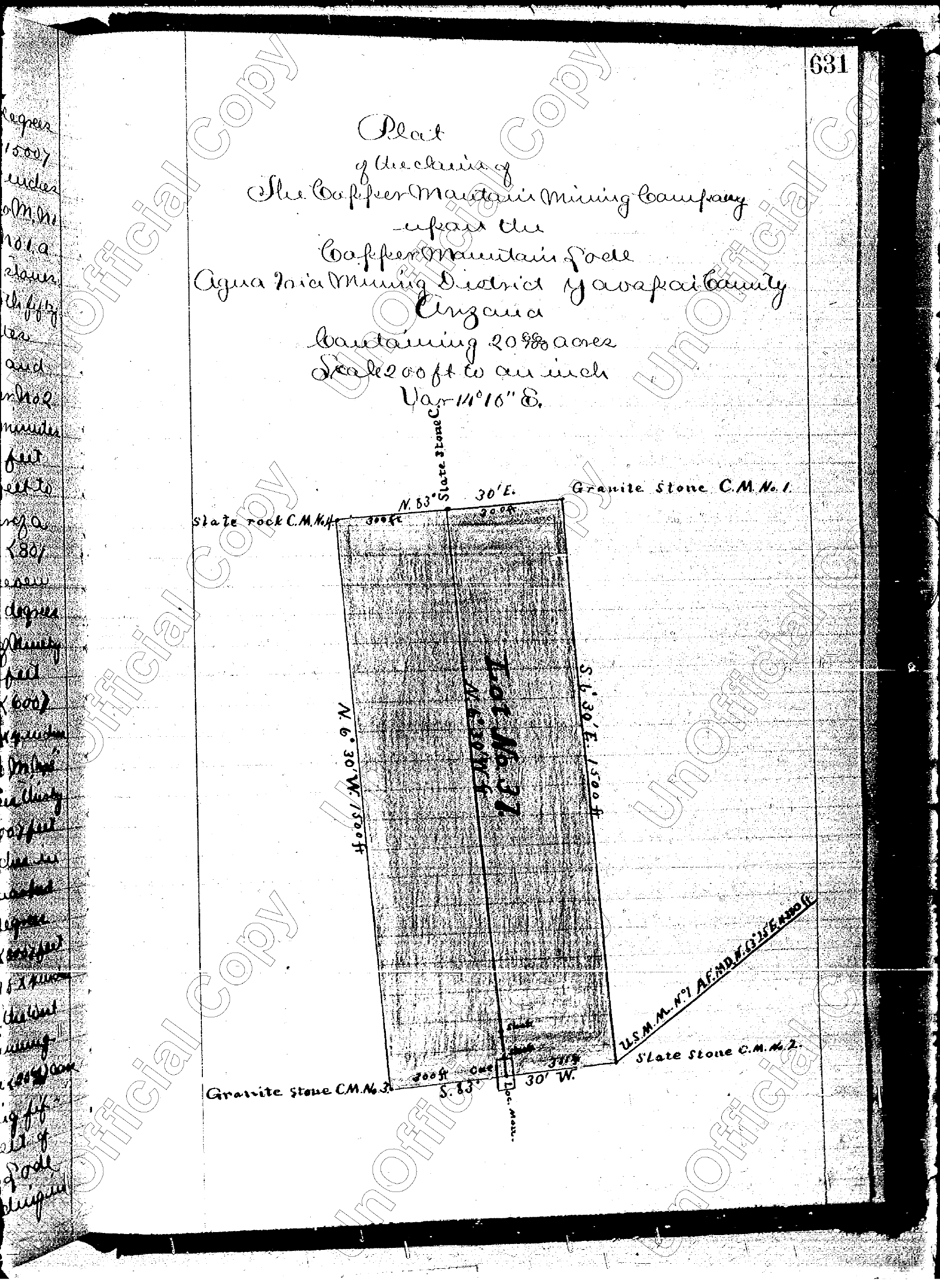
Lot No. 37
Copper Mountain Lode
Historic federal survey records approximately:
20.668Acres
Copper Mountain · Yavapai County, Arizona
Private Acquisition Opportunity — Yavapai County, Arizona
82.6± acres of historic patented mining property
A privately owned Arizona property with federal mining documentation tracing the Copper Mountain name to the 1880s. Historic federal records identify the Copper Mountain Lode within the Agua Fria Mining District of Yavapai County, Arizona, alongside additional patented mining claims documented in the property records.
Offered At$1,200,000
Historical records do not establish current mineral resources, reserves, grades, recoverability, or economic viability. Current acreage, title, mineral ownership, easements, and other property rights should be independently verified.
Why Copper Mountain
The mining history is in the record.
Federal mining records specifically identify the Copper Mountain Lode in the Agua Fria Mining District. The original federal survey identifies:
Copper Mountain Lode
20.668 Acres
Lot No. 37 · Agua Fria Mining District · Yavapai County
Additional historical records included with the property documentation identify the First South Extension Copper Mountain Lode, Expansion Lode, and Anglo Saxon Lode. More than a century later, Copper Mountain is available for a new generation to evaluate.
Documented Since the 1880s
Historical federal records identify the Copper Mountain Lode, Lot No. 37, within Arizona's Agua Fria Mining District. The original survey documents approximately 20.668 acres associated with the Copper Mountain Lode.
Additional historical records document other named lode claims associated with the property file, including the First South Extension Copper Mountain Lode, Expansion Lode, and Anglo Saxon Lode.
Federal mining documentation spanning generations — now available for modern independent evaluation.
Historic Lode Claims
Lot No. 37
Historic federal survey records approximately:
20.668Acres
Survey No. 38
Historic federal survey records approximately:
20.660Acres
Survey No. 2309
Documented as part of a federal mineral patent covering the Expansion and Anglo Saxon lodes.
Survey No. 2309
Included with the Expansion Lode in historical federal patent documentation totaling approximately:
43.322Acres (combined)
Historical patented acreage should not be interpreted as current marketed acreage. The historic lode claims total approximately 84.65 patented acres in the record, while Copper Mountain is marketed at 82.6± acres. Current boundaries, acreage, and title should be confirmed through current title and survey documentation.
Historic Federal Mining Patents
The property file contains historical federal mineral patent and survey documentation identifying named lode mining claims within the Agua Fria Mining District of Yavapai County, Arizona.
These documents provide prospective purchasers with a historical foundation for further geological, title, mineral-rights, land-use, and economic investigation.
Patented Mining History
Historical federal patent documentation associated with the property conveys patented mining premises together with the rights and appurtenances described within the original instruments — subject to the reservations, conditions, and existing rights contained in those records.
Current title and mineral-rights documentation available during due diligence.
The Modern Acquisition
A century of documentation, presented today as a single privately owned parcel available for acquisition and independent evaluation.
*Mineral rights and access reflect historical patent and easement documentation on record; all rights, boundaries, and acreage are subject to verification through current title and survey.
The Offering
Copper Mountain is brought to market without a modern exploration, drilling, or resource-definition program conducted by the seller — no speculative production figures are presented. We invite companies that understand these industries to investigate the opportunity themselves.
82.6± acres · approximately $14,528 per acre
More Than a Century in the Record
1883
Historical documentation associated with the Copper Mountain mining property dates to the 1880s.
1884
Federal documentation records the Copper Mountain and First South Extension mining properties.
1907
Additional federal patent documentation records the Expansion and Anglo Saxon lode claims.
1976
Later easement records continue to identify the Copper Mountain claim as Lot No. 37 and the Expansion claim as Survey No. 2309, showing continuity of those historic claim names in subsequent property records.
Today
82.6± acres being offered for acquisition and independent evaluation.
Geology + Material Potential
Different operators may see entirely different opportunities in the same 82.6 acres. What could it mean to your operation?
Mining + Exploration
Copper Mountain is associated with historic mining activity in the Agua Fria Mining District and offered with patented mining history. Mining companies, exploration groups, geologists, and mineral investors are invited to conduct their own investigation of the geology, historic workings, and mineral potential.
Request property information →Aggregate + Material
For aggregate producers, quarry operators, and material suppliers, Copper Mountain is an opportunity to independently evaluate the property's rock and material characteristics, accessibility, location, and potential compatibility with existing operations.
Explore the property →Decorative Stone + Specialty
For decorative-rock companies, landscape-material producers, and specialty-material businesses, Copper Mountain offers the opportunity to evaluate visible rock and material for potential commercial applications.
Request documentation →Strategic Acquisition
Private land, patented mining history, documented lineage, location, and long-term optionality come together in one Arizona property. For the right operator or investor, Copper Mountain may represent more than a land acquisition.
View acquisition details →Location
Mayer, Arizona | Yavapai County
Copper Mountain sits near Mayer within a region with a long history of mineral exploration, mining, and material production — letting prospective purchasers evaluate not only the property itself, but how it may fit within their operations, transportation, processing, customers, and long-term resource strategy.
Schematic corridor diagram, north up and not to scale — shown for orientation only. Copper Mountain lies along the SR 69 corridor near Mayer, between Prescott Valley and the I-17 interchange at Cordes Junction. Replace with an interactive map (with verified parcel location) before launch.
Historic Access Documentation
The property records include 1976 permanent, non-exclusive dirt-road easement documentation involving Copper Mountain and surrounding patented mining claims. Those records specifically reference the Copper Mountain claim, Lot No. 37, and the Expansion claim, Survey No. 2309, within the Agua Fria Mining District.
Access documentation available for review.
Part of a Larger Historic Mining Landscape
Historical access documents reference numerous patented mining claims in the surrounding area, including:
Surrounding claims are referenced in historical records for geographic context only and are not represented as included in this offering unless established by current title. Current legal and physical access should be independently confirmed through title, survey, and on-site due diligence.
Contact
For any inquiries or to discuss the property directly…contact me!
Mandy Pilgrim
Professional REALTOR®
Brokerage + Luxury Real Estate
Listing representation by Mandy Pilgrim · The Mini Cow Realtor
Copper Mountain — Yavapai County, Arizona
82.6± acres of privately owned Arizona property with documented federal mining history dating to the 1880s — presented to qualified mining, exploration, aggregates/materials, strategic land, investment, and acquisition groups for independent evaluation.
Offered at $1,200,000